After my recent anti-technology rant, here’s a post on smartphone apps for landscape painters.
These apps wont make anyone’s paintings better but they can facilitate putting oneself in a position where the focus is on the subject. The only surefire way to improve your painting with a smartphone is to use it as a black mirror.
I’ve switched recently to Android, so the links are to the Google store. I’m sure there are equivalents for iOS.
Weather
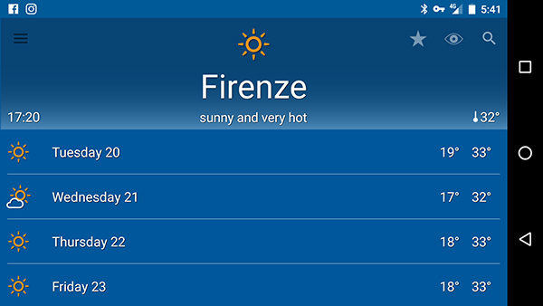
Il Meteo Weather App
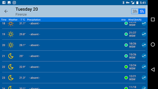
Il Meteo’s hour by hour prediction is usually very accurate.
Knowing what the weather will do is obviously incredibly useful. I wrote before about Il Meteo, the Italian meteorological website I use to predict weather for plein air painting. They also have an app. It’s the one I always check first as it’s accurate most of the time. It’s pretty general though, and for more specific information I use MeteoEarth ($10/year) which has cool little animations which show you wind direction, cloud cover, and precipitation for the coming days.
Meteo Earth’s animated cloud cover display.
It also shows wind speed and temperature but I prefer Windy for wind prediction, and after 25 years in Europe I still haven’t figured out what the numbers in celsius mean (I know 0 and 40). The third app I use for weather is Clear Outside, which forgoes the fancy maps and animations and just gives numerical values for everything. I find its prediction for cloud cover especially useful as it is normally accurate, and because it splits them into high, medium, and low clouds. It also gives the dew point, which can be useful for predicting how wet I’ll get when trudging to my spot in the early morning.

Windy wind-prediction app.
Clear Outside’s numerical weather forecast.
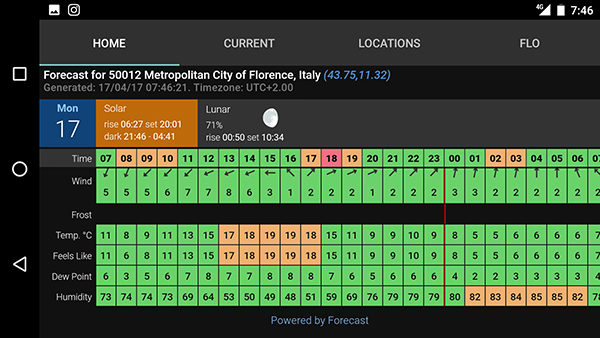
More Clear Outside, showing the dew point and humidity.
I usually check all three apps and follow the majority opinion.
For people in other parts of the world, RainToday (it only shows up in the UK app stores) seemed to work well for simple, short-term rain prediction in the UK, and NOAA and MyRadar get good reviews from painters in the US.
Sun Prediction
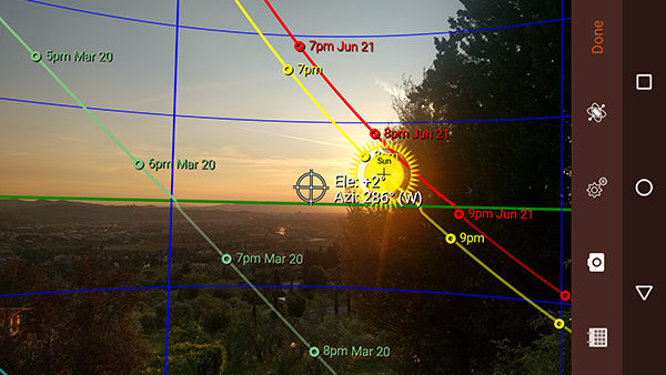
Sun Seeker’s sun-prediction augmented reality view.
There are a bunch of these for landscape photographers. My favorite is Sun Seeker as it does an augmented reality view where it uses your camera to overlay the sun’s path through your view. It also gives the positions at other times of the year, which can be useful if you have a particular subject that you want in a particular light. The other one I check occasionally is Exsate Golden Hour, but really just to check the sunset and sunrise times. It gives the time for the ‘golden hour’, but I think it’s different for painters than photographers as I consider my golden hour to last much longer than the app does. It also predicts stuff like ‘expressive skies’ based on whether it’s going to be partly cloudy at sunset. For calculating sunrise and sunset The Photographer’s Ephemeris can also calculate mountains that will shorten the day at either end, but it’s a confusing app and I don’t use it. I mention it because landscape photographers seem to love it. They have a desktop version you can try for free.
Maps
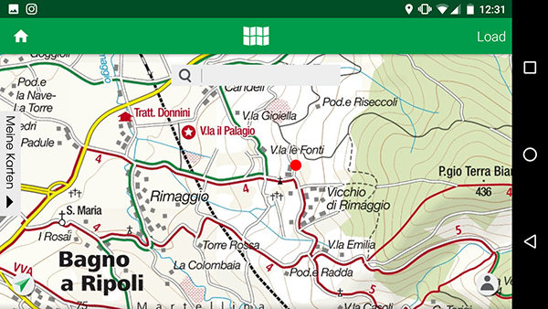
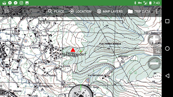
Kompass topographical maps
I find topographical maps to be very useful in scouting for landscapes. I can often calculate a good view by studying the lay of the land before I even start driving to the location. And they are especially well-suited to scouting in Italy as I can often predict the picturesqueness of a view based on the layout of the buildings (older buildings are rarely on a grid, and are usually much better for landscape painting). My favorite paper maps of Tuscany are made by an Austrian company called Kompass and some of my favorite painting spots were found using their maps, so I was quite happy to see they now have an app. It’s not as nice as having a paper map, but it’s certainly more convenient. Their library isn’t very extensive, but they do central Tuscany quite well (the only building they don’t have is the one I live in now). When I couldn’t find Kompass maps for an area, I would often use the Italian state’s (IGM) maps which are available via other apps like MyTrails and BackCountry Navigator.
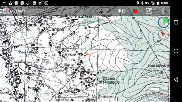
MyTrails using the Istituto Geografico Militare maps.
Istituto Geografico Militare map on BackCountry Navigator
The other map app I’ve played around with is Komoot, which has navigation instructions for hiking and mountain biking, and does a good job of knowing actual trails in the areas around Florence where I’ve tried it.
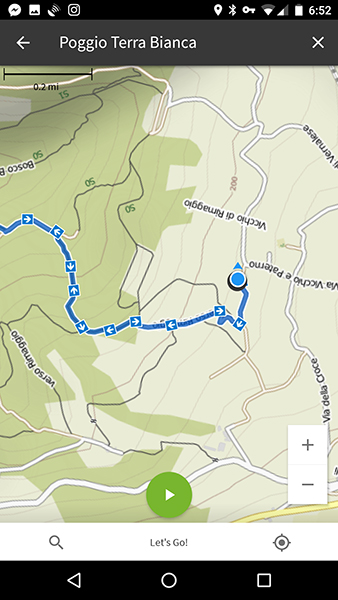
Komoot’s trail navigator.
Gaia GPS gets very high praise from hikers but, as it doesn’t show the buildings here in Italy, I prefer the other apps.
Lastly, Peakfinder and Peaklens can show you the names of mountains in your view, which can be useful for titling work.
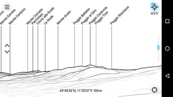
Screenshot of Peakfinder pointed over the rather uninteresting Arno valley.
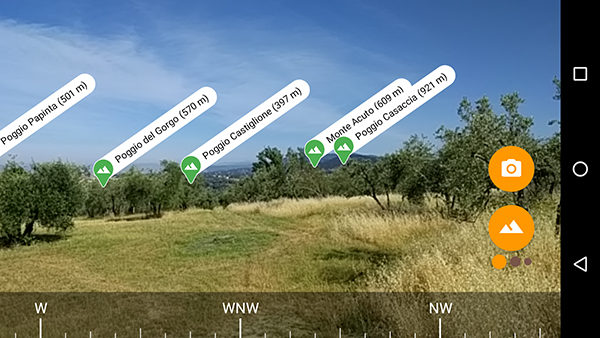
Peaklens’ augmented reality view (more or less the same view as Peakfinder above).
Drawing
I bought a Jot Pro stylus and tried a few drawing programs. I can see how it would be useful for thumbnails and for artists who feel more comfortable with digital media, but I still prefer a pencil and paper. I tried Autodesk’s Sketchbook, PaperOne, and Bamboo Paper. I think PaperOne was my favorite of the three as it felt the most like an actual pencil. Their lay-out leaves much to be desired though as the tools take up too much of the screen space. Autodesk felt the most polished of the three.
Thumbnail study done in PaperOne.
Thumbnail study done in Autodesk Sketchbook.
Thumbnail study done in Autodesk Sketchbook.
Sketch of Emma using the Bamboo Paper app.
Other stuff
I installed a bunch of photography apps, but just use the Android one at the end of the day. I’ve been using Lapse It Pro for making timelapses without lugging around my DLSR. I tried a few plant identification apps, including PlantNet, Tree ID – British Trees, and Whose Leaf Is It?, but I know most of the trees around here. I also installed an Emergency Room Map for Italy, and Wilderness First Aid at the suggestion of William Elston, but luckily haven’t needed to use either.
If anyone has any other app suggestions I love to hear about them in the comments.
Good suggestions.
I like “YR widget” for weather, in conjunction with Samsungs “transparent weather clock”. The yr widget only gives you 2 days prediction but it’s very quick and easy. The transp. Weather app gives me 5 days prediction at a glance, and since they are widgets, they are the first thing I see when I turn on my phone, no need to open up the apps.